


Projects
The 3D Virtual Buildings Project

The 3D Virtual Buildings Project (3DVB) originated in the 1990s, and did so for two reasons. First, it was one response to a 1998 book by Jack Granatstein called Who Killed Canadian History? Granatstein's book was controversial, critiquing both the country's commitment to teaching its own history, and the content that was taught. But the work also initiated something positive: scholars began to think and re-think how history was taught. Our project was one response to that process.
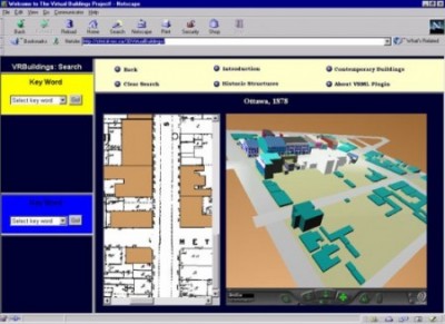
The 3DVB project was also a response to growing public access to the Internet, and to the emergence of new modes of computationally-supported expression, such as Virtual Reality. Educators, government policymakers and researchers began to wonder how these technologies could be leveraged to support education, and one outcome of that interest was the project, which was a joint initiative of the National Research Council, Industry Canada and the University of Ottawa. The project went on-line in 2000, and in its original iteration featured a low resolution VR representation of downtown Ottawa, Quick Time VR representations of commercial structures situated on Sparks Street, and an online tutorial which taught students how to make 3D models of 19th century structures using a CAD package called VectorWorks.
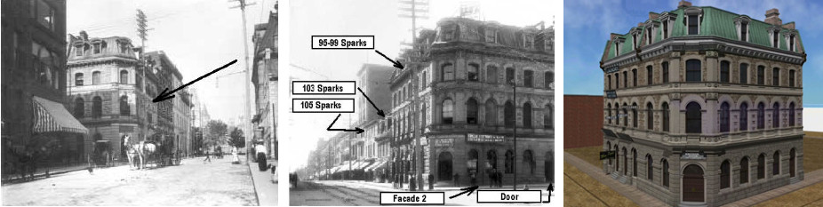
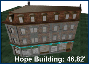
In 2005, the project moved with its principal developer John Bonnett to Brock University in St. Catharines. There, the project continued to employ the same teaching methods devised in Ottawa. The project's ultimate teaching aim is to teach students that they must distinguish historical models from the objects to which they refer. The "model" can be anything: a book, an article, or a 3D model. What we are trying to do is to teach our students to shed their trusting attitude towards any and all representations of the past. Instead, we want them to look under the metaphorical "hood" of the historical work they are examining, to assess a given author's use of evidence, and the power of his or her argumentation. We want to give students the tools they need to judge whether a given historical representation should command their respect. The way we go about providing those tools is by taking students through the process of constructing a historical model for themselves. We provide them with a limited number of sources, usually two photos and a fire insurance plan, and teach them how to translate the content in each source into a set of dimensions that they can then use to construct a model. The structure shown here is the commercial property of James A. Hope, an Ottawa stationer situated on the corner of Elgin and Sparks Streets in Ottawa in 1878.
While taking our students through the process of source translation and model construction, we are also able to visually show students tenets of the historian's craft, including:
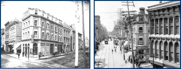
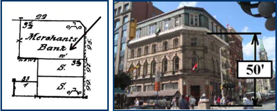
• The need for source criticism — Through examination of fire insurance plans, students learn quickly that primary sources often don't mean what they initially think. They further learn the need to learn about the origins of the sources they use, and the intellectual and practical contexts that gave rise to them. For example, based on the map shown here it would be easy to make an initial assumption that the Merchant's Bank was 50 feet high. That assumption would be wrong. The cartographers who inscribed building heights in fire insurance plans were interested in listing a specific thing: the height of a given structure's vertical walls. If that structure had a sloped roof, as the Merchant's Bank did in 1878, cartographers would list that section as a half story, and not include its contribution to building height. The 50 foot mark is actually situated at the point indicated in the contemporary photograph of the surviving structure, located on the corner of Sparks and Metcalfe Streets in Ottawa.
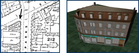
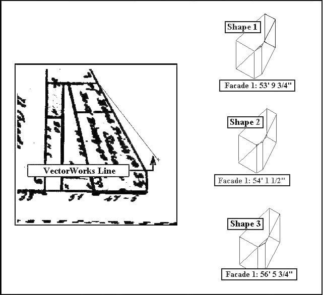
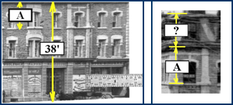
• Acceptance of Uncertainty — The project requires students to derive building dimensions from the analog representations contained in the fire insurance plans. While helpful, the sources also impose limitations on what we can infer about building dimensions. Consider the building footprint of the James Hope building shown here. The graphic shows the outline of the structure, and presents modelers with an important question: where should they trace? Should they align the lines generated by their modelling software in the middle of the thick line representing the Hope building, or along the right or left edges of those same thick lines? There is no obvious answer to that question, and each option produces three different results regarding the probable length of Façade 1 shown here. What the exercise shows students is that they can infer the length of each wall to a given order of magnitude. But it also shows that, barring discovery of an alternate method of measurement, they also have to accept a range of error that can be as long as 3 feet. While this constraint would be frustrating for 3D modelers seeking to generate a high quality model of this historic structure, it also presents a valuable pedagogical opportunity. It shows students that there are some instances in which historians are unable to move beyond the uncertainties imposed by their sources.
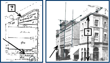
• The value of source interpolation — Students learn that they can learn more from their sources by using them in conjunction. One of the challenges they face in the tutorial is that their source map does not explicitly list the height of the James Hope building. However, this data gap also provides us with a way to show students that there is latent information in primary sources that can be retrieved by methods such as interpolation. The fire insurance plan contains the absolute height of neighboring structures. The photograph shows the relative height of all structures. By integrating the information contained in both sources, and using a little simple math, our students are able to learn that the structure's height was approximately 47 feet high.
These features and others associated with the 3D Virtual Buildings Project have been disseminated in both national and international journals, and via chapters in two edited books. The project’s pedagogy, website, and the results of classroom experiments are described in contributions in journals ranging from L’histoire sociale / Social History, one of Canada’s top-tier history journals, to Oxford University Press’ Literary and Linguistic Computing (now named Digital Scholarship in the Humanities), the leading international venue for digital humanities scholarship. Articles describing the project have also appeared in the Italian journal Storic@mente, Text Technology (simultaneously published in Computing in the Humanities Working Papers), and the Journal of the Association for History and Computing ( Later re-published in Edinburgh University Press' History and Computing, now The International Journal of Humanities and Arts Computing, at the journal's request ). The project was also featured in contributions to two edited books: Mind Technologies: Humanities Computing and the Canadian Academic Community (University of Calgary Press, 2006); and Construire une capitale – Ottawa – Making a Capital (University of Ottawa, 2001).
In the decade and a half since its release, national and international scholarly reaction to the 3DVB project has been both gratifying and supportive. David Staley in his widely cited book Computers, Visualization and History, praised its pedagogical method, noting: “Students fortunate enough to be taught history in this constructivist setting learn not only about the content of the past but the method by which the historian thinks about and reconstructs the past.” [David Staley. Computers, Visualization and History. 2nd Edition (New York: Routledge, 2015, c. 2002): 101-102]. In a 2009 speech to the Canada 3.0 Forum, Chad Gaffield, then president of SSHRC, concurred, praising the project for contributing toward “the redefinition of the curriculum” and “transforming what it means to be a student in disciplines like history.” [Chad Gaffield, “Canada as a Digital Nation in the 21st Century: the Innovative Contributions of the Social Sciences and the Humanities.” ( January 9, 2010 ) ].
The project tutorial has also been listed by the Canadian Architectural Archives as an architectural resource. Abroad, the UK website Intute praised the project in 2006 for “delivering on its conceptual aims” and “offering an invaluable and innovative contribution to humanities computing that will allow students to develop their understanding of history in sophisticated ways.” Intute was a consortium of British universities and institutions that included Oxford University and the British Library. Its website was devoted to highlighting the best sites on the Internet devoted to supporting teaching and research.
Library and Archives Canada PA 9252, C 3776; NMC-0010731
Library and Archives Canada PA 8765, PA 9060; NMC-0010731
Project Publications:
“Charting a New Aesthetics for History: 3D, Scenarios and the Future of the Historian’s Craft.” In L’histoire sociale / Social History. 40(79): 169-208. May 2007.
Mediating the Past in 3D, and how Hieroglyphs get in the way: The 3D Virtual Buildings Project.” In Mind Technologies: Humanities Computing and the Canadian Academic Community. (Calgary: University of Calgary Press, 2006): 201-224.
“Following in Rabelais’ Footsteps: Immersive History and the 3D Virtual Buildings Project.” In History and Computing. 13(2): 107-150. 2001 (Published 2004).
“Versando nuova linfa in una vecchia disciplina: Impiego del 3D per insegnare e rappresentare il passato." [English Title: "Pouring New Wine into an Old Discipline: Using 3D to Teach and Represent the Past."] in Storic@mente. 2004.
On-line journal available at:
http://www.storicamente.org/02_tecnostoria/strumenti/bonnett_ital.htm [March 1, 2016].
“New Technologies, New Formalisms for Historians: The 3D Virtual Buildings Project.” In Literary and Linguistic Computing. 19(3): 273-287. September 2004.
“The Oral Tradition in 3D: Harold Innis, Information Visualisation and the 3D Historical Cities Project.” In Text Technology. 12(1): 1-8. 2003.